Introduction to field documentation
It has not been possible within the current project to make the field documentation from both excavation campaigns digitally accessible. With a few exceptions (see field drawings and images below) we have chosen to concentrate our efforts on the later excavations.
Virtually all the field documentation is in Swedish. No translations have been possible within the framework of the current project but, where practically possible, translations of parts have been provided.
Otto Frödin’s excavations
Hans Browall has summarised the excavation documentation of these excavations in his publication of 2011 (p.40ff). All the documentation is held by the Antiquarian Topographical Archives (ATA) in Stockholm, i.e. the archives of the National Heritage Board (RAÄ).
Conducting excavations
Hans Browall has also described how the excavations were conducted (2011:40-52). This background is necessary for an understanding of the excavation documentation.
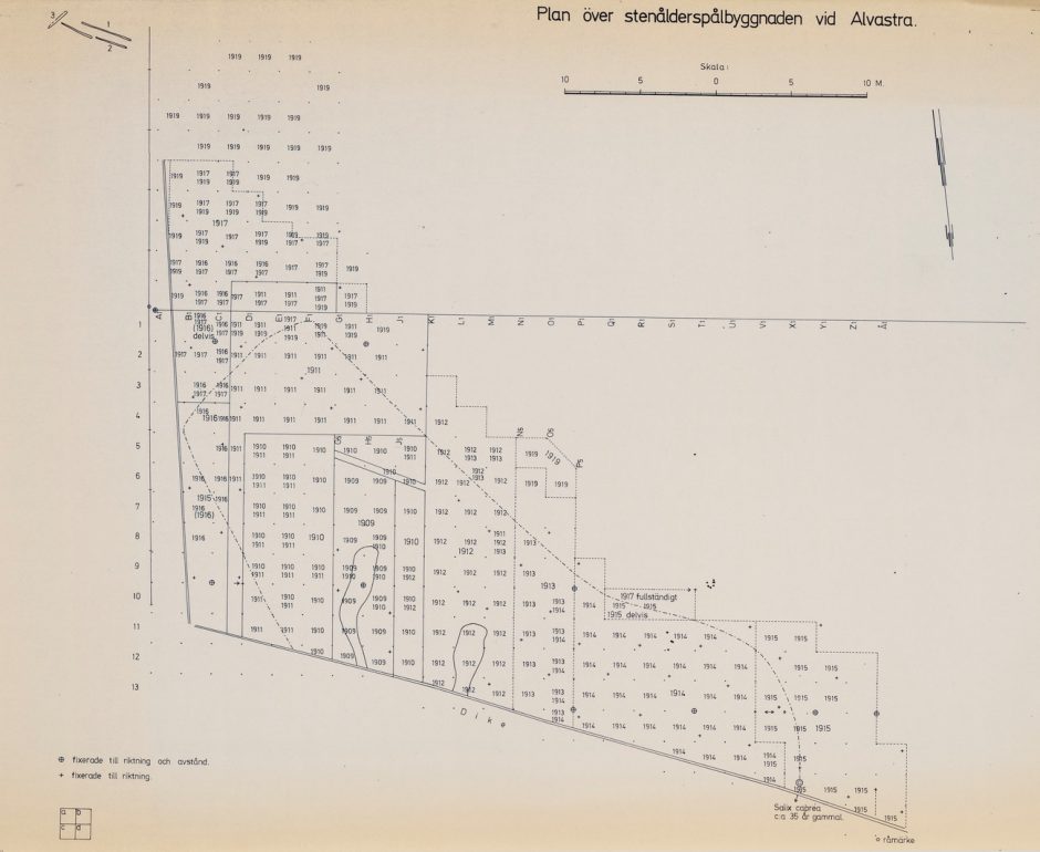
Fig 1. Otto Frödin’s coordinate system. This plans also shows which squares were dug in which years (1909-1919). The last three years (1928-1930) are not noted on this plan. NB: as the arrow shows, north is downwards in this plan.
The coordinate system was free-standing, based on squares measuring 2 x 2 m. laid out along a base line in an approximate east-west direction. Along the base line these squares were denoted by letters from A in the east to Å in the west. From the base line northwards, the squares were numbered first from 1 to 17 (fig. 1). Later (from 1911) it was found necessary to excavate the area south of the base line, these squares being denoted with Roman numerals from I to X. Thus, an individual square could be called P13 or CIII. Each square was further divided into four quadrants of 1m². From 1909 until 1919 (i.e. SHM accession numbers 13929 – 16374) the quadrants were denoted by lower-case letters, a in the southeast, b in the southwest, c in the northeast and d in the northwest (see the sketch in bottom lefthand corner of fig. 1). When the excavations were resumed after a break of eight years in 1928 (SHM accession numbers 18801, 19150 and 19414) this quadrant system was changed, a being in the southwest, b in the southeast, c in the northwest and d in the northeast. Thus, P13a denotes the southeast quadrant in the square P13 from 1909 to 1919 but the southwest quadrant of that square from 1928 to 1930.
From 1909 to 1919 vertical positions were all related to a point in square G6, denoted as 0. Vertical positions were above (+) or below (-) this point. This point was measured as 97,99 m a.s.l. In 1928 this point was lowered by 83 cm. In accordance, 83 cm must be subtracted from heights measured during the first excavation years (1909 – 1919) to be comparable with heights given for artefacts or features documented during the last three years of excavation (1928-1930).
For each square (2 x 2 m) a new series of find numbers was begun. This means that the finds did not receive unique numbers during excavation. The first find recovered in each square was numbered 1 and subsequent finds from the same square were numbered in sequence. A find number can be P13, 25 which is find number 25 in square P13. It should be noted that the sequence of numbers applies to the larger squares and not to the quadrants. Thus, if a find number is quoted as P13a,25, there cannot be another find that is denoted as P13b,25. The exact position of the artefacts that received a find number was mapped horizontally and vertically on field plans. Other finds, for example fragmentary or smaller objects and mass material, did not receive a number and their position was not mapped so exactly, often being positioned simply by the quadrant in which they were found.
Excavation documenation – diaries
| Diary | Otto Frödin | 1909-1917, 1917, 1923-1931 |
| Diary | Arvid Enqvist | 1917, 1919a |
| Diary | Holger Arbman | 1928, 1929-1930a, 1929-1930b, 1930 |
Fig 2. Diaries from Otto Frödin’s excavations according to Browall 2011:43f.
Excavation documentation – field drawings
| Scale | Made by: | Number | Reference | Available on this digital platform | |
| Trench plan | 1:133 | Browall 2011:figure 7 | |||
| Grid plan | 1:133 | Browall 2011:figure 31 | Plan | ||
| Find plans | 1:13,5 | 125 comprising 220 excavation squares | List of numbered finds in each square. Position of each find number marked. Find lists from these plans available on CD in Browall 2011: chapter 4 | ||
| Construction plans | 1:10 | Drawn in field probably by Holger Arbman and copied post excavation by Annika Boklund, National Heritage Board (personal communication, Hans Browall, 2019) | 119 comprising c. 238 excavation squares
|
postexcavation plans
|
|
| Hearth plans | 1:10 | 13 on 11 plans |
Fig 3. Field drawings from Otto Frödin’s excavations according to Browall 2011:44ff.
Excavation documentation – images
The archives contain 214 photographs taken during the excavations. 92 of these are digitally available in the photographic database of the National Heritage Board – (Kulturmiljöbild – KMB)
Hans Browall’s publication contains a table showing which excavation year the photographs were taken (Browall 2011:tabell 2).
161 glass negatives were taken vertically of the excavations in 1928 and used to make the photo plan which can be seen in Browall (2011: fig. 34). A further 34 images of individual features taken from the ground derive from the excavations 1928 – 1930. All these glass negatives were scanned by Hans Browall and are available on this digital platform. These images were not annotated when Hans Browall recovered them from the finds storeroom of SHM. He put much effort into the identification of the features which appear on the images (Browall 2011:50). Some images, however, show unidentified features. Browall’s information has been translated into English by Jacqueline Taffinder and the photo lists thus produced are available here 4.4.1. Here the images are listed in six different sheets: those taken in 1928, those taken in 1929, those taken in 1930, copies (kopior in Swedish and thus indexed K followed by number), those in unlabelled boxes (namnlös ask in Swedish and thus indexed NA followed by a number) and overviews (översikter in Swedish and thus indexed Ö followed by a number). ATA owns the copyright of these images and permission for publication on this site has been acquired. The features and excavation areas are numbered according to Browall 2011:85-155.
Mats P. Malmer’s excavations
Conducting excavations
Hans Browall has described the excavation techniques for these excavations (2011:386-387; 2016:23-29). The coordinate system was in this case also free-standing, based on squares of 1 x 1 m. The north-south axis is denoted as the x axis and the east- west as the y-axis. Coordinates in the excavation documentation are often abbreviated to two three-digit numbers, e.g. 226/407. The first three digits are always the x-coordinate and the last three the y-coordinate. The trenches in these excavations are orientated north-south. The plan in fig. 4 shows that there is a difference between north-south in Frödin’s excavations and north-south in Malmer’s excavations.
Z coordinates were measured using a fix point on the site which was mapped in relation to the national elevation system 1900 as being 99,14 m a.s.l. The system for numbering finds was the same as that used by Otto Frödin (see above).
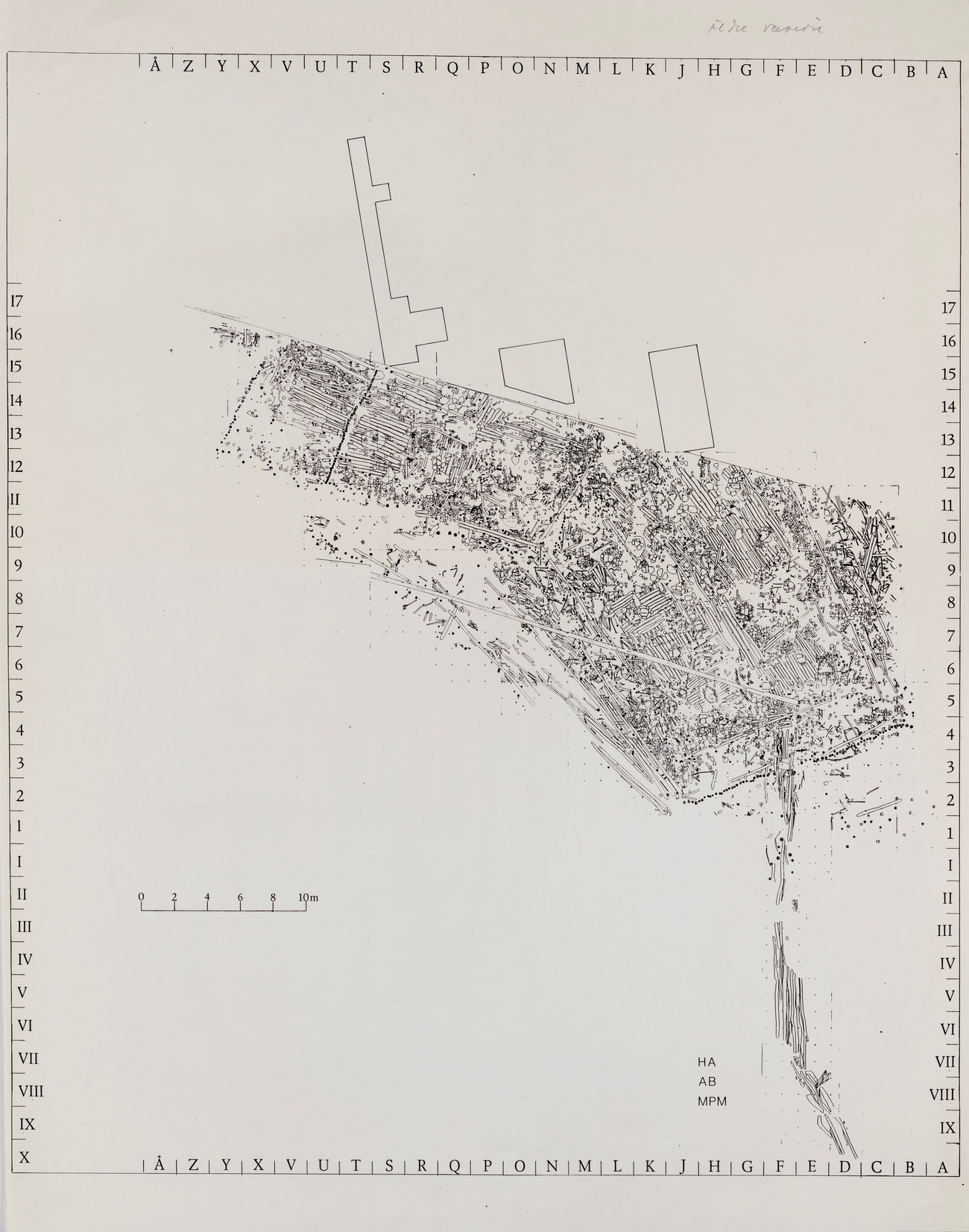
Fig. 4. The four main trenches in Mats P. Malmer’s excavations in relation to the large trench in Otto Frödin’s excavations. The squares are here denoted according to Frödin’s system (see above) but in the excavation documentation x and y coordinates are used. HA = Holger Arbman who directed the excavations for Otto Frödin from 1928-1930 (Browall 2011:37). AB = Annika Boklund who was a cartographer at the National Heritage Board and the person who produced the post-excavation drawings on the basis of Holger Arbman’s field drawings. MPM = Mats. P. Malmer who saw to it that the post-excavation drawings were assembled to make this grand plan.
Conducting excavation – contexts
| Feature | Number of records |
| Ash concentration or layer | 6 |
| Bark floor or layer | 94 |
| Brushwood layer | 41 |
| Cairn | 114 |
| Cultural layer | 29 |
| Hearth | 423 |
| Log floor | 437 |
| Total | 1144 |
Fig. 5. Number of records with recorded contexts in database. The total number of records in the database is 12481.
Within the present project the archaeological context has been registered if it was immediately available together with the objects. The contexts themselves are seldom numbered or given some other unique identity.
The other context information consists of the Z-coordinate. This is often exact in case of finds mapped in three dimensions. If the finds were recovered from the sieves, they have often received an interval between two Z-coordinates. Hans Browall describes the excavation of the Western trench where artificial layers of 5 or 10 cm were used (Browall 2016:29, appendix 4). In the Middle trench Stefan Bergh has described the vertical stratigraphy as being regulated by the horizontal features found in that trench (middle trench). The layers are described as bark floor layer, log floor layer and under log floor layer. The uppermost layer is described as the bone/pottery layer (p. 7).
Excavation documenation
The excavation documentation from Mats P. Malmer’s excavations is comprehensive. In 2013, when it was held at the Swedish History Museum, Hans Browall recorded it as consisting of 14,9 shelf metres, one set of five drawers containing field drawings, 186 other storage containers and a large number of individual documents. Some of this documentation has been scanned by the current Alvastra project and is now available on this digital platform (images, written documentation, field drawings, post-excavation drawings). The remaining documentation has been ordered and systematised by Erica Nyström, the archivist of the Swedish History Museum and transferred to ATA.
Written excavation documentation
The first part of this section is entitled written documentation. It consists of diaries, report manuscripts, sample ledgers, pile ledgers and photo lists.
Written excavation documentation -diaries
All the diaries found among the excavation documentation have been scanned.
Written excavation documentation – report manuscripts
Several unpublished manuscripts are available for the Eastern trench, two versions by Mats P. Malmer and one by Anders Carlsson (Eastern trench 1, Eastern trench 2, Eastern trench 3). The report manuscript denoted Eastern trench 2 was in the archives contained in a file titled “manuscript fragment” and it is an older version of one of the chapters in report manuscript Eastern trench 3. It was replaced in 1985, presumably by the version in report manuscript Eastern trench 3. This fragment also contains two other versions of page 48 in this chapter and one other version of page 49. The manuscript for the Middle trench was written by Stefan Bergh (Middle trench). These manuscripts were written during the 1980s or 1990s and they are by no means complete.
Written excavation documentation – samples
Sample ledgers for all trenches have been scanned. Genus and/or species identification of the wood samples are sometimes included in these ledgers (Eastern trench) and are sometimes available as separate lists (other trenches: Middle trench, Trial trench, Western trench). Identifications of genus/species of wood samples were made by Thomas Bartholin.
Written excavation documentation – photo lists
The documentary material from Mats P. Malmer’s excavations had been stored for 35 years in various places before the start of the present project. This has invariably led to discrepancies between the photo lists and the actual photos. In some cases, the lists include films that have not been found among the field documentation. All photos that the present project has found have been scanned.
Written excavation documentation – photo lists – Eastern trench
There are two photo lists for this trench – photo list I and II. Both are avaible here.
Photo book I contains the following lists:
1976 – Black/white and colour films are numbered in sequence. Films 1, 3, 4, 5, 7 are black/white while 2 and 6 are colour.
1977-1980 Black/white films until film number 19 in 1980.
1977-1980 Colour films
Photo book II contains the following lists:
1980 Black/white films 20-31
Written excavation documentation – photo lists – Middle trench
There is only one photo list for this trench . Lists of the black/white photos are available for 1978, 1979 (not for film 15) and 1980 (not for films 7-54). It is possible that the photo lists for the Eastern trench’s 1977 black/white photographs, film 8, 9, 12 and 14 are for the Middle trench.
There do not appear to be any photo lists for the 11 colour films taken from 1977 – 1979.
Written excavation documentation – photo lists – Western trench
There are two photo lists for this trench. These lists also include photos taken of the Trial trench and the New Trial trenches. In 2016 Hans Browall, as part of the current project, corrected the photo lists kept during the excavations and his hand-written corrections have also been scanned.
The first book contains lists from 1976 to 1980, beginning with black/white photographs and finishing with colour films. The second book lists photos taken in 1980, first black/white and then colour.
Written excavation documentation – photo lists – piles
The piles were photographed in the field in 1977, 1979 and 1980 and were numbered in a series from 1 to 817. In 1979 and 1980 the numbering system was changed, the digit 1 being added to the beginning of the pile number. Thus, pile number 817 became 1817. Both systems occur in different contexts and it is important to know that pile 817 is identical to pile 1817. For example, the four-digit number is used on labels displayed together with the piles in the photographs shown on this platform from 1979 and 1980. In 1977 the three-digit number was used. Many piles were documented in several images. In the indexation used here a lower-case letter is used after the pile number to refer to the different views of one pile. 1977, 1979, 1980 lists the images of the piles available here. The first three columns show the year of photographing, the number of the film used and the number of the picture in the film. This information is repeated in pile ledger 1.
Written excavation documentation – pile ledgers
Two of the ledgers documenting the piles have also been scanned and are available here. They list 884 or 886 piles and contain different kinds of information. Piles 818 to 886 have not been photographed. The first pile ledger contains the most information. The genus identification in column four here is by Thomas Bartholin who has also provided information on the season of the year and which year in the floating chronology of the pile dwelling the tree was felled (columns five and six). Designations used to denote the season of the year seem inconsistent or difficult to understand (fig. 6). The seventh column contains information on the photo documentation of the various piles both in colour (Swedish F and black/white, Swedish S). The film and picture number of the colour photographs should correspond to the information in the first three columns of tables in photo lists for piles 1977, 1979 and 1980. This ledger also contains in the last column comments on traces of working visible on the pile.
The second pile ledger contains other information that is important. The position of the piles in the various trenches is documented as X and Y coordinates. For piles 221 to 886 additional information has been recorded in the columns to the right. The Z coordinate of the pile top is recorded in the first of these narrow columns to the right. In the next column the inclination of the pile is shown, i.e. how many degrees from vertical and in which direction. The last of these narrow columns does not often contain any information. According to Hans Browall (e-mail 2018), this column was intended for the excavation square of Frödin’s trench.
| Code used in ledger | English | Swedish |
| Ye or Ve | ? | ? |
| W | Winter | Vinter |
| H | Autumn | Höst |
| F | Fall | Höst |
| F-S | Fall-Summer | Höst-Sommar |
Fig. 6. Designations for season used in pile ledger 1
| Swedish | Latin | English |
| Al | Alnus | alder |
| Alm | Ulmus | elm |
| Asp | Populus | aspen |
| Apel | Malus | apple |
| Björk | Betula | birch |
| Brakved | Frangula | buckthorn |
| Ek | Quercus | oak |
| Gran | Picea | spruce |
| Hassel | Corylus | hazel |
| Kornell | Cornus | Dogwood |
| Lind | Tilia | linden |
| T.ex. körsbär, plommonträd | Prunus | e.g. cherry, plum tree |
| Sälg | Salix | willow |
Fig. 7. Translations of tree genera used in pile ledger 1
Excavation documentation – images
Photographic documentation is digitally available both in black/white and in colour for all trenches. Information about the photos can be found in the photo lists. The photographs themselves are indexed according to the table below:
| Trench | |||||
| Eastern | Ö for Eastern (Swedish Östra) | Year of excavation | S for black/white (Swedish svart/vit)
or F for colour (Swedish färg) |
Number of film – a new series for each year | Number of picture – a new series for each film |
| Middle | M for Middle | Year of excavation | S for black/white (Swedish svart/vit)
or F for colour (Swedish färg) |
Number of film – a new series for each year | Number of picture – a new series for each film |
| Western, Trial, New Trial | 1 – number of file containing pictures. This information is superfluous and is not contained in the photo lists | Year of excavation | Separate series for colour and black/white photos | Number of film – a new series for each year | Number of picture – a new series for each film |
Fig. 8. Indexation of images from Mats P. Malmer’s excavations
This indexation is the key to the identification of the photos in the photo lists and thus to the information about the images. The images are collected in three folders, one for each trench in Mats P. Malmer’s excavation. The images for the Trial and the New Trial trenches are in the same folder as those from the Western trench. Each folder also contains a copy of the photo list for the relevant trench.
Note:
Some images had been removed from their position in the excavation documentation to be placed in a file used by Mats P. Malmer when he gave lectures on the Alvastra pile dwelling. We were unaware of the contents in this lecture file when we sent the images to the Kiruna Centre for Cultural Property as part of the project The Alvastra pile dwelling – an archaeological resource. These images were thus not scanned in Kiruna. They have as part of the project been replaced in their correct position and marked “not scanned in Kiruna”. A few of these images were scanned at the Swedish History Museum and have often been used to illustrate various sections of the digital platform. They are marked “scanned 2014”.
Most of the piles have been de-accessioned (read more about that here) but they were very carefully documented during the excavation project directed by Mats P. Malmer. They were photographed in black/white and in colour. The colour images have been scanned and are available on this platform.
Excavation documentation – field drawings
Chapter 4.7 contains a list of the field drawings and the post excavation drawings that have been scanned and are available in here. The drawings are plans, sections or profiles and for the Eastern trench projected profiles or sections. The latter is described by Browall (2011:386). In projected profiles all artifacts were mapped in two dimensions. The drawings from the Eastern trench were photographed by Gabriel Hildebrand at the Swedish History Museum before the start of the current project. The other drawings have been scanned at the Kiruna Centre for Cultural Property as part of this present project. After excavation copies were made of some of the field drawings, sometimes several field drawings were compiled into one. Some of these copies have been scanned, being indexed as post excavation drawings (prefix PE).
The following references on this page have no web links:
Browall, H. 2011. Alvastra pålbyggnad, 1909-1930 års utgrävningar. Kungl. Vitterhets Historie och Antikvitets Akademien. Handlingar. Antikvariska serien 48. Stockholm.
Browall, H., 2016. Alvastra pålbyggnad. 1976-1980 års utgrävningar. Västra schaktet. Kungl. Vitterhets Historie och Antikvitets Akademien. Handlingar. Antikvariska serien 52. Stockholm.